By Patrick McGrady
Special to The Dagger
What is redistricting?
Every ten years, according to the US Constitution (Article 1, Section 2), every State in the Union must reallocate House of Representatives district lines according to the decennial Census.
Each State has the right to determine how to draw their district lines, but they must be drawn equally in number. A Supreme Court case from 1964 (Reynolds v. Sims) stopped States from drawing lines with hugely variable population numbers.
Why do we need to draw or change current Congressional Districts?
There are only 435 members of the House of Representatives. People are mobile and this means that large population shifts can occur over a ten year people in between Censuses.
For example, the 2010 Census indicate that the populations of New York and Ohio have not grown as fast as others and as a result, they both will lose 2 House seats in the current redistricting cycle.
Other states have had stronger growth, so they gain seats. Texas will gain 4 seats, and Florida will gain 2.
Maryland’s population grew 9% between the 2000 Census and 2010 Census, so we are neither gaining nor losing a House seat.
How does Redistricting Work?
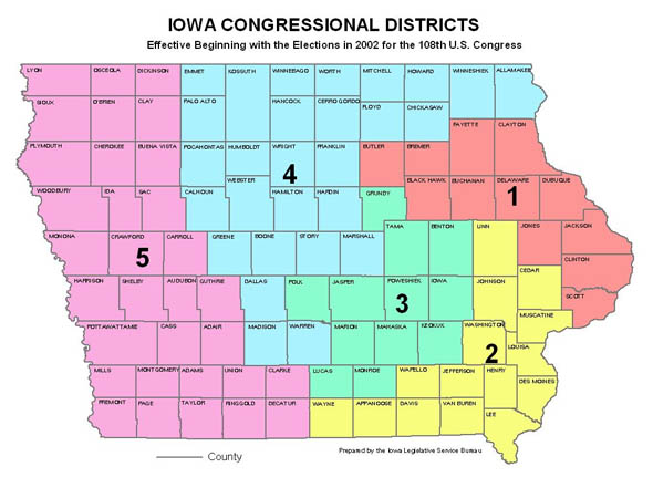
21 States use a commission to draft the legislative and Congressional districts. States like Iowa remove all political affiliations from the process, and end up with Congressional districts drawn by County, that look like this map:
The other 29 States twist politics into the district-drawing process. Often, we end up with maps drawn like Ilinois’s Congressional District 4 (below) or Maryland’s Congressional District 2.
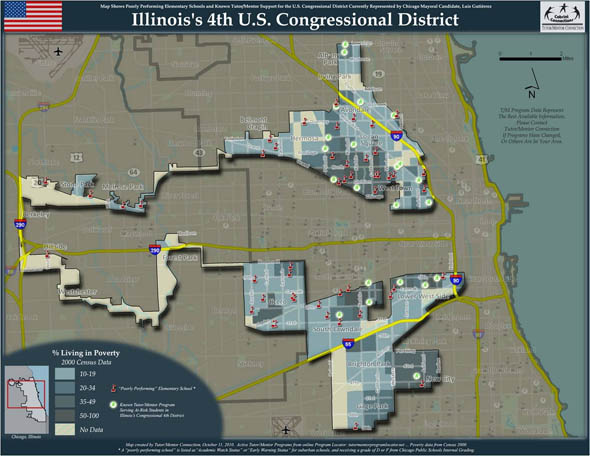
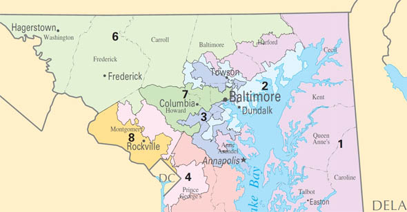
These maps are formed by politicians who seek to use the process of redistricting to achieve political gains– they effectively pick voters based on how they vote, instead of on geographic or community-based lines.
Like Illinois district 4, often these districts are only a single street wide, and can span hundreds of miles to achieve the desired political goals. Illinois CD-4’s purpose is to connect two Hispanic communities in Chicago.
These lines destroy community and almost guarantee poor representation in the US House of Representatives. How can a representative work for all of his constituents if they needlessly span hundred of miles and have no similar characteristics?
By picking their voters, the politicians are destroying any possibility of good governance by cementing incumbent politicians in place and using their power to limit try and limit debate.
What is “Gerrymandering?”
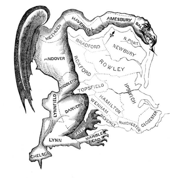
When a political process is used to create districts like Illinois CD-4 and MD-2, it is called “Gerrymandering”. This term comes from 1812 in Massachusetts, when Governor Elbridge Gerry used politics to draw a map to help political cronies. In the newspaper, this image was printed, cementing “gerrymandering” into the American lexicon.
How does redistricting happen in Maryland?
In Maryland, the State Constitution gives guidance on the State legislature redistricting, but not on Congressional Redistricting.
Traditionally in Maryland, the Governor of the State prepares a plan (through the Maryland Department of Planning) and then delivers the plan to the legislature.
The Governor creates a commission to hold hearings across the state, “listening” to what Marylanders think their district should look like, but the real process is undemocratic and secretive.
The plan prepared by the Maryland Department of Planning for the Congressional Redistricting is delivered to the Legislature and then voted on for approval.
The Congressional districts are drawn as politically as possible so that the most Maryland Democrats can win. This results in maps like the one above, from the 2000 redistricting.
Back in the 2000 redistricting cycle, Governor Glendening made the most of his last year in office by offering a Congressional plan that would secure a 6-2 split between Maryland Democrats and Republicans in Congress. This is why we have the maps we do today in which:
-Harford County is split in to three Congressional districts
-Baltimore City (with just enough people for a total CD) is split into three districts
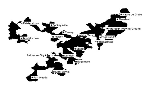
-MD-2 runs from Havre de Grace to Dundalk to Reisterstown and to Fort Meade, while staying out of Baltimore City.
Here’s a link to that district, or see the image below. http://www.govtrack.us/congress/findyourreps.xpd?state=MD&district=2
Why does this matter to you, and what can you do about it?
As you can see, the Maryland House of Delegates and State Senate work with the Governor (all of the same party) to draw districts that secure incumbent power while working against the people of Maryland.
There are two distinct paths that the legislature can go down during this cycle of redistricting cycle. A plan has been proposed by the Maryland Republican Party that draws lines based on County borders and keeps communities compact.
See the map here:
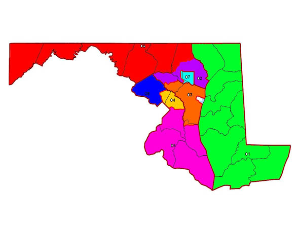
The map they presented was praised in the Washingon Post here:
http://www.washingtonpost.com/opinions/a-model-redistricting-plan-from-the-maryland-gop/2011/07/13/gIQAiee0GI_story.html
The other alternative could be an even more divided and destructive map that will try to secure total Democratic Party dominance over the state at the detriment of communities everywhere. Something like this district:
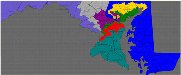
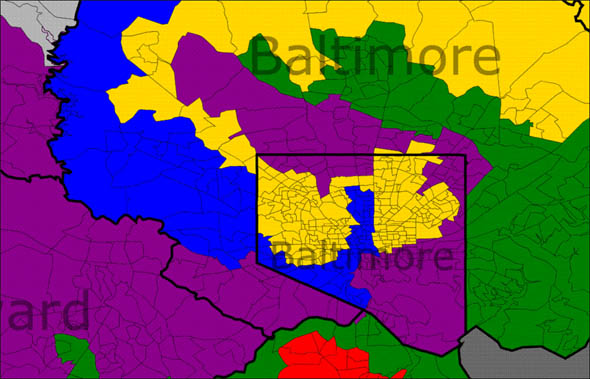
A zoom look shows how intense the Gerrymandering could be:
What’s the point? These Congressional lines are going to be cemented this October in a special session of the Legislature. The statewide hearings have begun already.
In another smack to the people of the State, you must sign up in advance of the meetings by email and either email or bring a hard copy of testimony that you provide. Please attend and consider testifying.
Here’s the link to the State page about the hearings: http://www.mdp.state.md.us/redistricting/2010/publicHearings.shtml
Saturday, August 27, 2011
Harford Community College
Amoss Center (next to Harford Technical H.S.)
Starts at 11:00 a.m.
200 Thomas Run Road
Bel Air, MD 21015
Parking all around school
Public Testimony Advance Sign-in
Saturday, August 27, 2011
Towson University
Stephens Hall Theater
Starts at 2:00 p.m.
8000 York Road
Towson, MD 21252
Public Testimony Advance Sign-in
Saturday, September 10, 2011
Chesapeake College
Todd Performing Arts Center
Starts at 4:00 p.m.
1000 College Cir
Wye Mills, MD 21679
Here’s what I want you to take away from this long piece:
Politicians –whether you share a party affiliation or not– should not be able to draw you out of your community. You are not just an R (epublican) or a D (emocrat) on a map– you matter.
When you talk to your elected Delegates and Senators, tell them that they should take the politics out of redistricting and draw the lines based on PEOPLE, not PARTY.
Voters should pick their elected officials. Politicians should not be able to pick their voters!
Discuss this topic live with Patrick McGrady and Maynard Edwards at 8 a.m. Wednesday on WAMD 970 AM.


Don’t worry people of Maryland, you can trust Martin O’Malley and his gang. You will be fairly represented with higher taxes, higher fees, gay marriage, benefits to illegals, more regulations, etc., etc., etc. Oh yes, you will receive fair representation once O’Malley has his shot at redistricting.
We will remember all of your arguments and see what the Harford County Council does with the map that it’s all-Republican Redistricting Commission has offered. If they want to change something their own party draws up, the first question on my mind will certainly be, Why???
Gerrymandering, indeed.
Wendy–
Please do remember all the arguments. But now, please make an argument to defend the way that the districts are drawn.
Or is it impossible for a Democrat to defend their position?
No one is defending the current districts. I believe Wendy is saying that the GOP arguement that the democrats (which make up 75% of the state) are the boggyman and will get you is rediculous in light of the Harford County redistricting issues.
Democrats make up 75% of this state? Really?
Sorry you are right 56% as of June 2011 with the GOP making up 26%, 14% unaffiliated and 4% other.
Thank you for the honest answer. I didn’t know what the number was, but I thought 75% was a bit high.
To be fair the GOP plan splits counties as well in an interesting way. Baltimore County is seperated from the Hereford zone, Northern PG and Easertern Moco are split and Howard County seems to be split into three districts as well as a tine sliver of Calvert county. Not quit as county like as suggested. more compact though.
Also does the tie dye effect map posted here have any basis in fact or is it a scare map? If we get the GOP map will Andy Harris still claim COckeysville as his home or will he use his Cambridge address!
Good points, CDEV! Let us also not forget that Tom DeLay was one of the architects of the Texas redistricting effort after the 2000 census. This is the same Tom DeLay who was convicted of money laundering early this year.
Tom, you are wildly off base and ignore the realities in Maryland.
Communities from Cecil County to Prince George’s to Frederick to Baltimore City lose when the Democrats in Annapolis muscle their will onto the people.
Communities lose when Republicans do it too, but we don’t have that problem in Maryland.
Until we do, I want to see the President of the Harford County Young Democrats make the case for why it is OK to draw lines like this.
By virtue of the fact that Republicans in the House of Representatives are holding our credit rating hostage and Moody’s states that Maryland is one of five states that could suffer should the country default, we do have problems of Republican muscling that could affect Maryland.
Tom,
One could just as easily say that the Senate and President are the ones holding the credit rating hostage. And I think all states will suffer should we default.
We, MAryland will suffer even without default. We have a large percentage of federal employees and contractors who stand to lose their jobs thus reducing revenues to the state!
I think we should lock them all in a room with no cameras and feed them bread and water until they work out a deal.
CDEV, to be fair, Baltimore County, Montgomery County and PG county would all need to be split based on populations. I would personally have the eastern shore counties with Harford and a smidge from Baltimore county as one district. The western counties with a smidge from Baltimore as another disctrict. The rest of Baltimore County as a third district. For the 4th, I would have have most of Montgomery county. The 5th would be Baltimore City and a smidge of AA county. The 6th would be Howard, the remainder of AA county. The 7th would be The rest of Montgomery county and roughly 56 percent of PG. And the 8th would be The rest of PG along with Charles, Calvert and St. Mary’s.
Of course, this is just based on grabbing a map with the populations for the counties on it and figuring out what fits best. I am sure all the politicians out there would complain about it.
As for Andy Harris, well, he shoudl not be allowed to change his residence for a couple years.
Tom, yep, it happened in Texas as well. Happens all over the place. Look at New York’s gerrymandered map, and Massachusetts as well.
Congressional Districts need to have about 720,000 people in them. As a result, counties have to get divided (unless the population is divided like it is in the Iowa map above).
But Baltimore City has just enough people for a Congressional District, so why should it get chopped up? We are seeking uniformity of community.
It looks like the Western District includes the Rural parts of Baltimore for the sake of Community, but I don’t know.
The Voter Rights Act also mandates that they keep “majority minority” districts. The GOP plan is better for everybody. Of course, the average person can submit a plan too, and they should. Google “Maryland Redistricting” and look at the second link– the MD State page.
I agree with you in alot of ways if Baltimore City has the magic number in it it should remain in tact as is.
Calvert Charles and St. Mary’s counties are economically and socially linked along with Southern PG. The southern end of PG has grown in density alot over the last 10 years.
I think better then putting the Herford zone and Carroll COunty in the Western district Fredrick county as a whole is a better fit. put Carrol and Baltimore County together (not sure if a split from Howard may be needed).
I think the GOP plan does still lead to a 6-1 or 5-2 split with the MD-1 as the wild card and weather Dutch can still win his district. Not sure why it felt the need to include the little sliver of Calvert in the Anne Arundel district instead of just using less PG to acieve the desired number.
Baltimore City has about 620,000 people. Baltimore County has about 805,000 people. Each should be mostly their own district. If you have Garrett, Allegany, Washington, Frederick and Carroll counties together, you would still be short about 60K or so populations wise. Same for the Eastern Shore counties and Harford. You would be short about 30K or so. Pull the shortage of population from Baltimore County for each of these and you have three districts.
Of course, that would make sense, so it would never happen.
Last election year two states, California and Florida, had initiatives on their ballots to remove party registration and election results from the redistricting formulae. Just like we did with the in-state tuition to illegals effort, here in Maryland we need to let Annapolis know that if they continue to gerrymander our state the people will unite and get this on a future ballot. We probably can’t do much to change things this year, but if we allow this to continue the situation will be no different in 2020, 2030, 2040, etc.
I believe you are thinking of two different processes. One is the referendum, which we have in Maryland. If the legislature passes a bill, registered MD voters may gather signatures to force that piece of legislation to the ballot, to be passed or failed by the people and not by the legislature. (See Article XVI of the MARYLAND CONSTITUTION.) The other process is the initiative, in which the voters, by petition, are able to initiate the legislation. The people basically introduce the bill and the voters pass or fail it. We do not have that second process in Maryland. We can ONLY counteract a piece of legislation that our legislature has passed.
I, like you, would also like to see the elimination of party affiliation from the criteria used for redistricting.
Districts should be drawn using GIS software with factors such as neighborhood, city, and county lines (and population, of course) considered. Party registration and racial/economic demographics shouldn’t be involved in the process at all.
I don’t trust any politician from either party. Most of them will say anything to get elected (and especially re-elected) and cater to their big donors rather than what is best for their constituents, counties, states, and the country as a whole.
Republicans are too blind and beholden to the far right wing to recognize the fact that tax increases are going to be necessary to fix this mess that they helped create. Democrats are too blind and beholden to the far left wing to recognize the fact that significant spending cuts must happen and that all facets of the budget must be up for cuts.
Good suggestion with GIS. You are being way too nice when describing the behavior of R’s and D’s. I find them quite repulsive even more so recently.
Although mandated by law this is a great excuse for the maryland Dems to get together and raise taxes.raise fees and give more taxpayer money to illegals and those who refuse to work. Anyone who couldn’t see this coming at the last election must have been on another planet.Its all about getting reelected not about the citizens of MD or the US.
Gerrymandering and carving out these silly districts is one of the worst affronts to democracy we have.
One of the funny things about this process is that it is stated that gerrymandering forms districts based on the way people vote, not where they live, but many times, when you look at it, where people live seems to be pretty directly related to how they vote. I’m not sure which influences which, but there’s clearly a relationship there. So how much difference might it make?
Also, consider for a moment that you have one, or only a couple representatives for the city of Baltimore, as opposed to having it split up as it is now. That would mean that one or two of the reps are going to be exceedingly powerful and influential with respect to the federal dollars that come down the pike for all kinds of programs that are heavily utilized in Baltimore, and maybe nto so much in other areas. Is it a good idea to consolidate that influence?
It’s never an easy thing, redistricting. But there is obviously room for improvement in MD. We need to reform the process, like so many other things.
And after its done, most of the people will still have no idea what the name of their congress critter is.
Just don’t make one of those Klan for liberty pandering clowns my representative!!!!
And please dont make Dutch is out of Touch or Obama’s best friend Elijah Cummings my congressman!
I would like to be rid of ANdy “where is my Healthcare” Harris.
Mr. McGrady,
Thank you for making our voters aware of how key redistricting is in a democracy. Few pay enough attention to these details and wonder why Democrats have controlled this state for so long. I really wonder if anyone could get a court to declare gerrymandering. Once again, check the parties of most judges.
This game is an interesting simulation
http://www.redistrictinggame.org/index.php?pg=game
this is too
http://redistricting.greatergreaterwashington.org/#