From the National Aeronautics and Space Administration:
NASA will be conducting a month-long series of research flights beginning as early as June 27 with an aircraft flying at 1,000 feet above the Interstate-95/Baltimore-Washington Parkway traffic corridor. The flights will be visible from Baltimore southwest to the Washington Beltway and northeast to the Delaware State line. The flight path will also pass over the Chesapeake Bay Bridge near Annapolis.
The flights are part of a study of urban air pollution NASA is conducting in cooperation with the Maryland Department of the Environment, the U.S. Environmental Protection Agency, and several universities. The campaign is called DISCOVER-AQ, which stands for “Deriving Information on Surface Conditions from Column and Vertically Resolved Observations Relevant to Air Quality.”
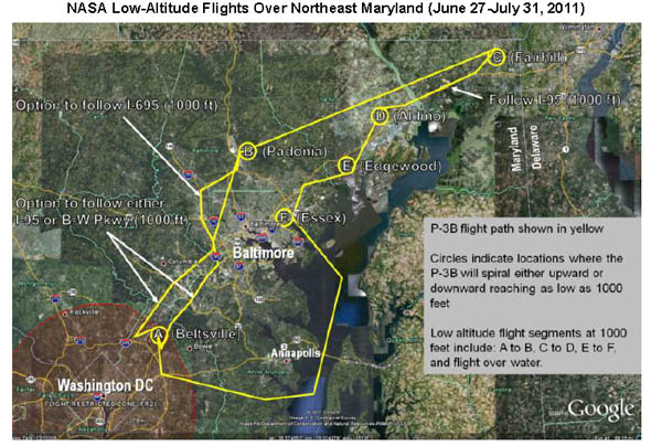
The low-altitude flights by NASA’s P3 aircraft will follow a regular route shown by the yellow line in the map on the next page. The plane will fly this route several times during a day’s flight, which can last up to 8 hours. Flight dates will be determined by weather conditions and announced by NASA by 5 p.m. the day before a flight. Flight times can range between 6 a.m. and 8 p.m. Up to 14 flights will be conducted through July.
NASA has coordinated closely with the Federal Aviation Administration to ensure these research flights are conducted in a safe manner. FAA has also assisted in public awareness regarding the flights.
Flights Planned between June 27 and July 31
Two NASA research airplanes will be flying over northeast Maryland to study urban air quality and help scientists improve their ability to measure ground-level air pollution from space. The field campaign is called DISCOVER-AQ, which stands for “Deriving Information on Surface Conditions from Column and Vertically Resolved Observations Relevant to Air Quality.” The flights are being conducted in cooperation with the Maryland Department of the Environment, the U.S. Environmental Protection Agency, and several universities.
One of the aircraft, NASA’s P-3B, will be flying at low altitude — about 1,000 feet. Approximately 14 flights are planned, starting no earlier than June 27 and ending by July 31. Specific flight dates have not yet been scheduled but will be determined based on weather conditions. Announcements of P-3B flights will be posted to this website by 6 p.m. the day before a flight is planned. Flight times can range from 6 a.m. to 8 p.m.
Location of Low-Altitude Flights
The low-altitude P-3B flights will be easily viewable along the Interstate 95/Baltimore-Washington Parkway traffic corridor from the Washington Beltway northeast to Baltimore and continuing on to the Delaware State line. The flight path will also pass over the Chesapeake Bay Bridge near Annapolis. Each flight will follow the same route, shown as a yellow line on the map. The aircraft will retrace this route several times during a day’s flight, which can last up to 8 hours.

NASA’s P-3B Research Aircraft
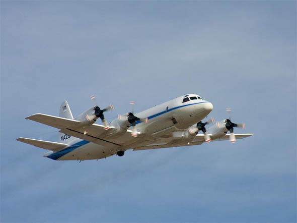
The P-3B aircraft is a 117-foot four-engine turboprop carrying a suite of nine scientific instruments that will sample the air the plane flies through. The P-3B will fly spirals over several ground measurement stations along the route (shown as yellow circles on the map). These profiles will extend from 15,000 feet to as low as 1,000 feet from the ground. Home base for the P-3B is NASA’s Wallops Flight Facility in Wallops Island, Va.

For more information on the project, visit: http://www.nasa.gov/discover-aq


Another great waste of “stimulus” money
Pollution is so much better than “wasting” stimulus money. Don’t you breath the same air I do?
Pollution is horrible. However, while they’re flying this 4 engine prop job out of, apparently Wallops Island which is off the map they’re showing, I’m left wondering how many tons of CO2 they’ll contribute to the problem. Why not base out of Martin or somewhere temporarily? Afterwards, when they have numbers, what exactly can they do with them beyond telling us there is more pollution in the air – or less when it’s windy?
The EPA is charged with handling pollution issues, not NASA. Oops, I guess the EPA is too busy shutting down energy producing plants in WVA, OH, and PA. They don’t have time to make up and chase down levels of pollutants in the Northeast. What about NOAA? NASA was created for our country to explore space beyond the many layers of spheres that surround our planet.
Why is NASA conducting this ??
Is a study needed to decide if there is a pollution problem in the area ?!?! For years I’ve heard about cleaning up the bay and it just gets worse. Rte 40 is a superfund, and most of the water can’t be swam in…now in a economic depression we’re spending tons of money to see if I-95, one of the most heavily traveled highways has pollution between Washington and Balto – REALLY ?!?!
I think one of the problems with the whole clean up the bay program is the lack of education effort on the part of it’s organizers. A quick look at the Bay watershed will show that while Maryland hosts the Bay, there is more watershed area in both Pennsylvania and Virginia. Money spent here will not halt the flow of contaminants from those states. Every bit of farm fertilizer, pesticide, fungicide, herbicide, animal waste, storm drain run off with used oil, used antifreeze, etc. from half of Pennsylvania ends up in the river. Just go look at what piles up against the dam some time and you’ll get a glimpse of just the stuff that floats and doesn’t dissolve. That would be a good way to show Pennsylvanians what they’re doing.
Agree that this is a waste in terms of the design of this study at least based on common sense, not some PHd justification. Sure we need to do air quality studies from time to time. But I-95 … I can tell you some results right now – its poor on some days and getting worse on others – not good for man nor beast.
NASA? Not on his one buddy. This is EPA and the NOAA. Mission creep and cost all over the federal gov’t costs money. And Congrsses’ oversight committees are so disjointed that they can’t even find these poor practices.
Interesting photo of the P3. I hope they spiral long enough to allow all the pollution the plane is spewing out to dissipate – looks like the equivalent of dozens of cars WITH anti-pollution equipment… Gee, pollution along the highway. Who would have believed it. We should get money to see if the water in the Bay is wet.
LMAO !!
Feels like a little too much complaining from people who probably don’t have any idea what they’re talking about.
I’m not going to make you think I know what I’m talking about, because I’m no scientist. But let’s point out a few things:
1. It says right in the article that NASA is conducting the project in cooperation with the EPA and other agencies. So would you rather that the EPA buy their own plane and duplicate something NASA is already doing? Sounds cost effective to me.
2. It also says right in the article that the project is designed to improve our ability to measure air pollution FROM SPACE. Last I checked, the EPA didn’t do much in SPACE. It could be that it ends up being more cost effective to use a satellite to measure pollution in a wider range of places than it would be using planes. Maybe it isn’t, I dunno.
Now that’s not to say it might not be more cost effective to have a private business perform this experiment, chances are it would be. But we all know that’s not how our government works, typically.
I would just be surprised if anybody here, including myself, is qualified enough to judge this a boondoggle. There’s definitely not enough information in the press release to indicate either way, in my opinion.